|
Note: To make things easier for travelers headed to this fascinating region, I have used the simplified, locally used names of towns and villages. For example, the town of Xinjiezhen is sometimes called Old Yuanyang, but locals, bus and taxi drivers, know it as Xinjie.
Over 1000 years ago, the Hani and Yi peoples of Southwestern China began clearing dense forests and carving farmland from the steep hills and rugged mountains of what is now Yunnan Province. Using only simple handmade tools and beasts of burden such as the strong, gentle water buffalo, the hard-working people of this region have toiled for centuries on their fields. Rice is the world’s most important food crop, and China is its largest producer and consumer. Rice farming requires vast amounts of land and water. To grow rice in the Ailao Mountains at 1600 meters above sea level, the Hani and Yi people crafted a seemingly endless maze of rice terraces. Cascading down the steep mountains like giant steps, the local people built an incredibly complex and effective irrigation system to move water from the heavily forested mountaintops down to the terraced fields. In addition to rice, they also grow other staple crops such as soya, corn, and cabbage. Animals, including buffalo, chickens, cows, ducks, and pigs, are common here, seamlessly integrated into the landscape.
In this part of the world, farmers grow only one rice crop per year. Planting coincides with the start of the rainy season, which begins around mid-April. The harvest begins in late August or early September. Around November, after the harvest, farmers flood the terraces with water to keep the soil moist and prevent collapse. Much of this water evaporates, forming clouds that drift up the valleys and above the mountains, returning water to earth as rain. Over the past 1300 years, the Hani and Yi people have created a unique and self-sustaining ecosystem. 
traveltoasiaandback.com - Hani style, Shengcun, Yuanyang County, Yunnan Province
The Cultural Landscape of Honghe Hani Rice Terraces
In 2013, UNESCO declared over 1,000 square kilometers of Yuanyang County a World Heritage Site. Officially known as the “Cultural Landscape of Honghe Hani Rice Terraces”, the site includes 82 villages, many with old traditional houses built of earth and stone. These “mushroom houses” are three-storied structures with thatched roofs. Easily identifiable by an official UNESCO plaque, traditionally, villagers kept livestock on the ground floor, lived on the second, and used the third for farming equipment, rice, and corn.
The three principal terraced areas in the UNESCO zone are Bada, Duoyishu, and Laohuzui. 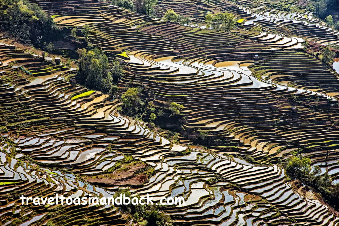
traveltoasiaandback.com - Bada rice terraces, Yuanyang County, Yunnan Province, China
Bada
Located 14 km (25 min.) from Xinjie town, the Bada rice terraces and “Bada Scenic Area” are one of the three highlight areas. The terraces blanket a deep valley flanked by high mountains. Several villages and viewing platforms are perched on the mountainside overlooking the terraces. The best time to view and photograph these terraces is late afternoon before the sun sets behind the mountains.
A one-day pass, which allows unlimited access to all the platforms, costs 70 CNY (RMB) or just over $10 USD. 
traveltoasiaandback.com - Sunrise over Duoyishu, Pugao Laozhai Village, Yuanyang County, Yunnan Province, China
Shengcun
Located 3.5 km (10 minutes) from Bada Rice Terraces, Shengcun is the largest town in the UNESCO area. This normally sleepy little town comes to life a few times a week when it hosts a lively and colorful market. Although most participants are Hani and Yi, other ethnic groups also attend the busy market.
Both the Shengcun and Xinjie markets are scheduled every four days by the Chinese zodiac calendar. For example, Xinjie market is held on rat, dragon, and monkey days, whereas Shengcun market is held on rabbit, sheep, and pig days. For travelers unfamiliar with the Chinese zodiac calendar, the Yunnan Explorer website has a calendar and interactive map listing markets and festivals held in Yunnan Province. An interesting trekking route connects Bada and Shengcun via "the cliff viewpoint" and Shangzhulu Village. 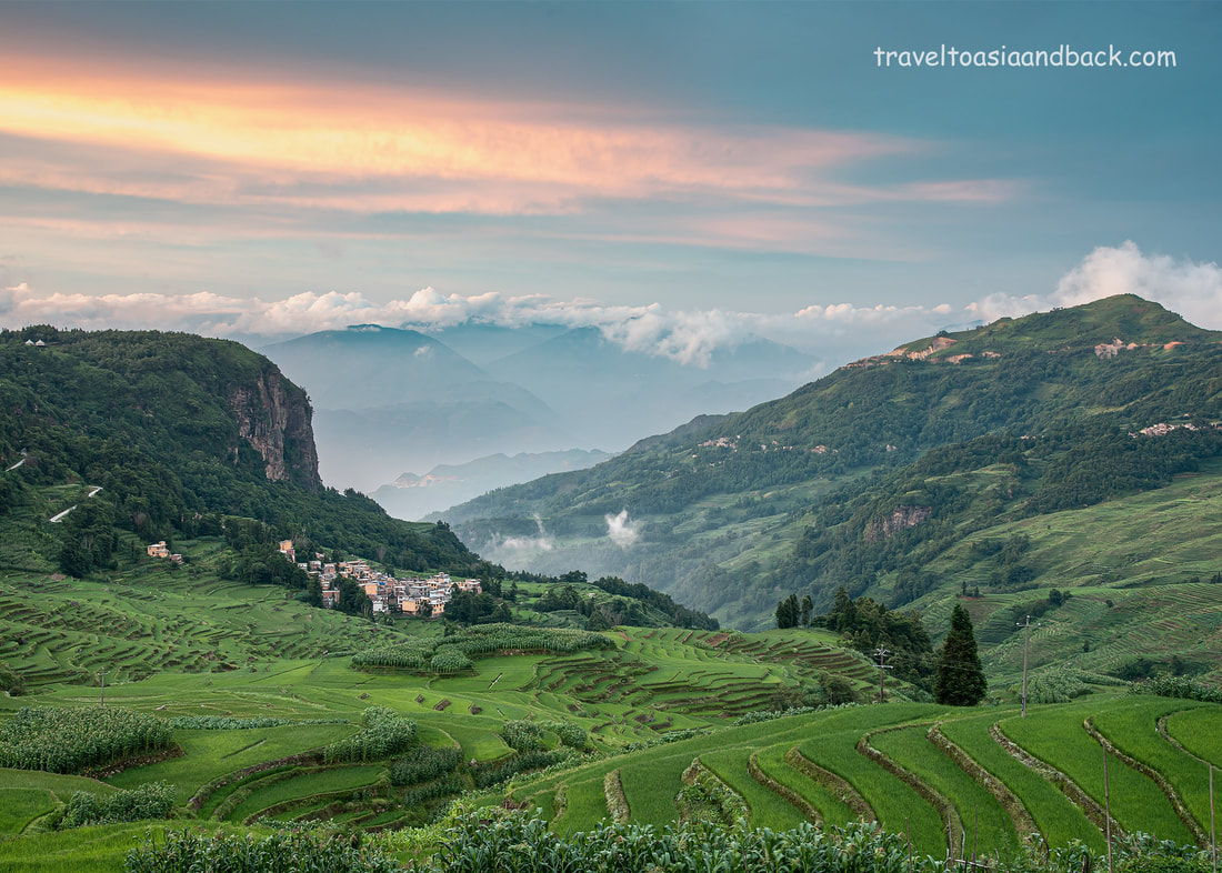
traveltoasiaandback.com - The rice terraces of Douyishu, Yuanyang County, Yunnan Province
Duoyishu
Located 23 km (40 min.) from the town of Xinjie, the enormous swath of steep rice terraces here is well known as the best place to view and photograph sunrise. A large viewing platform on the main road towers above villages nestled amongst the terraces. Lying in the valleys between high mountains, the terraces take on a dreamlike quality as the sun rises and clouds ascend the valley, filling the gap between the cliff to the west and the mountains to the east. When the conditions are just right, the sun’s rays reflect off the clouds and water-filled terraces, producing spectacular colors. The villages overlooking Duoyishu make good bases to explore the area.

traveltoasiaandback.com - Duoyishu Rice terraces, photographed from Huang Cao Ling Village
Huang Cao Ling Village
On the west side, and high above the Duoyishu terraces, sits Huang Cao Ling Village. This is an excellent place to photograph sunrise from hotel rooftops and allows easy access to the “Duoyishu Terraced Fields” viewing deck. This is a large multi-level platform attached to a hotel. The platform is open from 06:00-18:00 and collects the 70 CNY (RMB) admission fee mentioned previously.
The viewing platform can be extremely busy at sunrise. Photographers shooting on a tripod should be at the entrance gate before 06:00 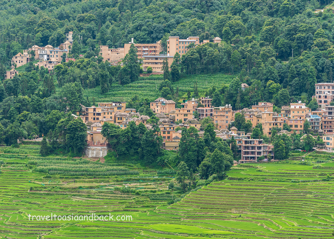
traveltoasiaandback.com - Pugao Laozhai Village, Yuanyang County, Yunnan Province
Pugao Laozhai Village
One kilometer east of the Duoyishu viewing platform is Pugao Laozhai. This Hani village is approximately 500 meters downhill from the main road connecting Duoyishu to Xinjie. Situated above the center of the Duoyishu terraces, the village “Moon Square” is a great place to view and photograph the terraces. The village has numerous homestays, hostels, and guest houses.
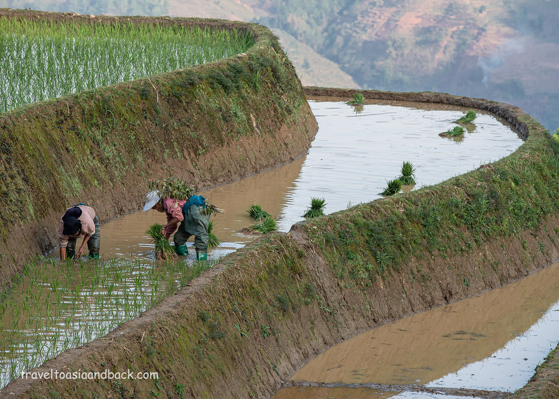
traveltoasiaandback.com - Planting rice in the Hani rice terraces of Yuanyang County, Yunnan Province, China
Laohuzui
Also known as the “Tiger’s Mouth” this area of very steep terraces and villages is considered to be the best area to view and photograph sunset. Two viewing platforms can be found here, the highest one giving visitors a panoramic view over the valley, while the lower position allows photographers the opportunity to get tighter shots of the terraces.
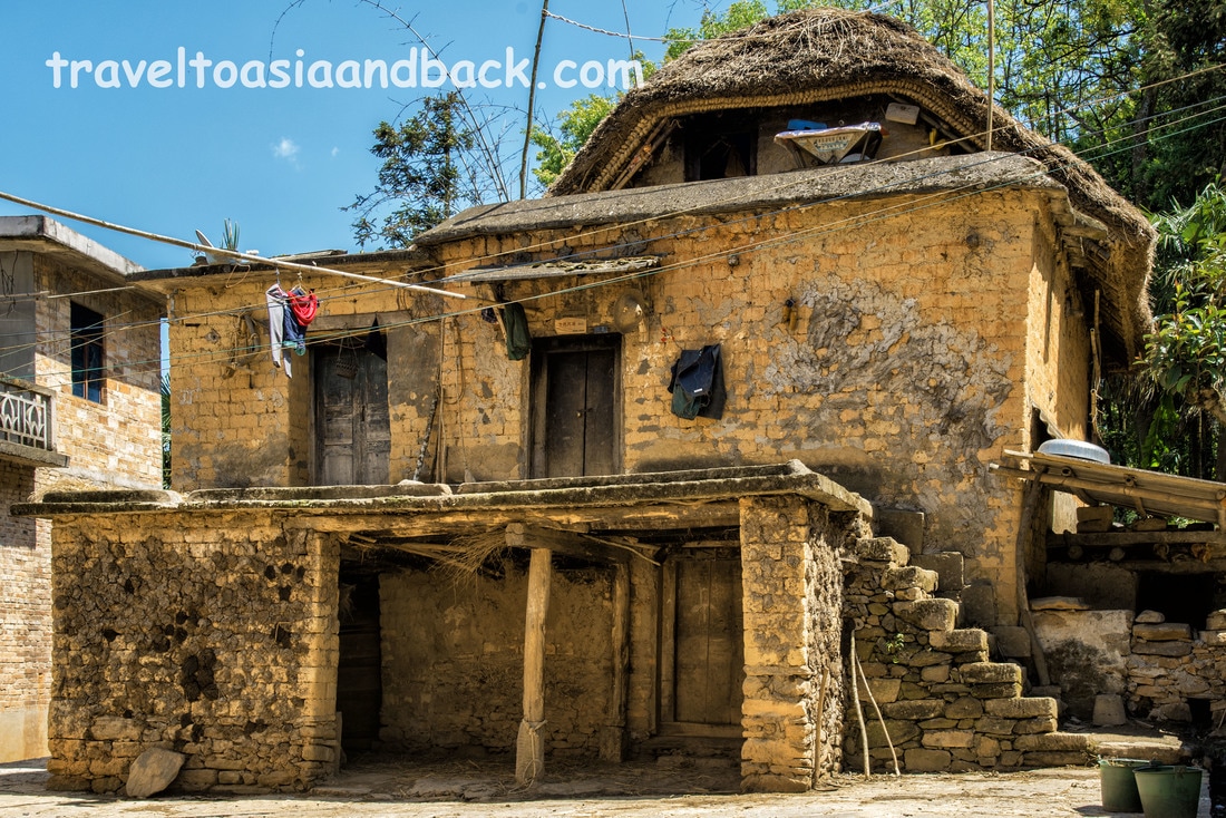
traveltoasiaandback.com - A typical Hani mushroom house, Yuanyang County, Yunnan Province, China
Trekking in the Hani Rice Terraces of Yuanyang County China
The area’s most popular activity is trekking between the villages and the rice terraces. Villages, towns, and farmers’ fields are joined by paved roads and narrow trails. The roads are relatively easy to walk on, even uphill, as the grade is fairly low. A guide really isn’t necessary, which is good, as it can be difficult to arrange English-speaking guides. A good map or mapping app on a smartphone is extremely useful.
Smartphone Mapping Apps in China
I have to admit that I am addicted to Google Maps and use the app constantly. Google Maps does work in China; however, to use all the features, you need a Virtual Private Network (VPN). Even with a VPN, Google Maps lacks detail and is inaccurate in rural China.
To avoid using a VPN, many travelers purchase e-SIMs before arriving in China. I have recently bought e-SIMs from Trip.com. They are easy to install and work very well. A better choice for mapping apps, often recommended by Chinese residents, is maps.me. Also known as "Maps With Me", MAPS.ME has global coverage using GPS with maps downloaded on your device. The App is fully functional even when offline. Most importantly, the China maps on MAPS.ME provide far more detail than Google Maps. In 2023, I switched to a different version of MAPS.ME, another app based on OpenStreetMap (OSM) called Organic Maps. It's basically the same as MAPS.ME, and it works very well. In 2025, I added Amap (Gaode Map) to the mix. This is an English-language application from China that works very well and has fantastic features for DIY travelers. However, all of these programs have features I like and dislike, so I use all three, often all at once. 
traveltoasiaandback.com - Hani costume, Pugao Laozhai Village, Yuangyang County, Yunnan, Province
Travel to the Hani Rice Terraces of Yuanyang China
There is no airport or railway station in Yuanyang County; it is only accessible by private vehicle or bus. Bus travel in China is reasonably inexpensive, safe, and comfortable. Buses play an important role in rural China, transporting not only passengers but cargo. Operating like FedEx or UPS, residents routinely call bus companies to pick up and deliver boxes and small packages. Even the smallest towns have at least one modern and efficient bus station. The Hani Rice Terraces can be reached by bus from popular travelers’ destinations including Hekou (5.5 hrs), Jianshui (4 hrs), Jinghong (8 hrs) and Kunming (7 hrs).
However, before reaching the terraces, you will first go to either Xinjie or Nansha towns, then take a minibus or shared taxi to your final destination. 
traveltoasiaandback.com - Duoyishu Rice Terraces, Yuanyang County, Yunnan Province, China
Nansha
Nansha is a small town 310 kilometers south of Kunming, which serves as a local bus transportation hub. If you are traveling from Hekou or other parts of southern Yunnan Province, you may very well pass through or stop here. Although Nansha is labeled “Yuanyang” on Google Maps and referred to as “New Yuanyang” in guidebooks, it is a solid two-hour drive from the famous rice terraces.
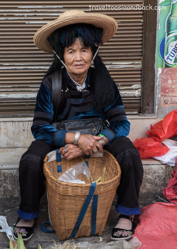
traveltoasiaandback.com - Hani costume, Xinjie, Yuanyang County, Yunnan Province
Xinjie
This small town, located 25 kilometers from Duoyishu, is the last bus transportation hub before reaching the terraces. If you are traveling from Kunming or Hekou, this will be your destination and gateway to the Yuanyang Terraces. The town has numerous hotels, guesthouses, and restaurants and can be a base to explore the area. Countless shared taxis and taxis run between Xinjie and the villages scattered amongst the terraces.
Several times a week, the town hosts a local market that appears to cater mostly to minority ladies, particularly the Hani and Yi. This market provides visitors with an excellent opportunity to view and purchase typical ethnic clothing and accessories. Mike Pollock
|
 RSS Feed